
The concept of URBANFLUXES introduces novel ideas on how anthropogenic heat emissions can be observed from space, that’s why it was selected for funding under the first H2020 Space Call and more specifically under the topic H2020-EO-1-2014 “New ideas for Earth-relevant space applications”. URBANFLUXES will exploit the Copernicus Sentinels observations, which are expected to provide improved data quality, coverage and revisit times, increasing the value of Earth Observation (EO) data for scientific work and future emerging applications. These observations can reveal novel scientific insights on the detection and monitoring of anthropogenic heat emission, thereby generating new EO opportunities.
Since the rate of warming in cities is higher than the average global warming, both urban planning and Earth system science communities need spatially disaggregated anthropogenic heat emission data; such information is practically impossible to derive by point in-situ fluxes measurements, while satellite remote sensing is considered in URBANFLUXES as a valuable tool for estimating the Urban Energy Budget (UEB) parameters. The basic idea behind URBANFLUXES is to break down UEB and to quantify the anthropogenic heat flux patterns of day and night, week and weekend, summer and winter times, by combining observations form different Copernicus Sentinels satellite missions. The anthropogenic heat flux is the heat flux resulting from vehicular emissions, space heating and cooling of buildings, industrial processing and the metabolic heat release by people. In URBANFLUXES, the UEB is considered in the context of a volume because of the three-dimensional nature of cities:
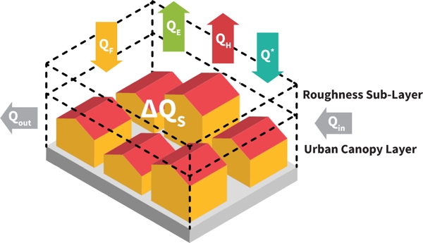
The urban surface energy budget is defined: Q* + QF = QH + QE + ΔQS + ΔQA + S, where QF is the anthropogenic heat flux, Q* is the net all-wave radiation flux, QH is the turbulent sensible heat flux and QE is the latent heat flux, ΔQS is the heat storage, ΔQA = Qin – Qout and S represents all other sources and sinks, within the control volume shown in this figure.
The major challenge for URBANFLUXES is the innovative exploitation of Copernicus Sentinels data to estimate the spatiotemporal patterns all UEB fluxes. The main research question is whether EO is able to provide reliable estimates of anthropogenic heat flux for the time of the satellite acquisition. URBANFLUXES will address it by combining Sentinels observations with conventional meteorological measurements, developing new methods for estimating each UEB term. The energy balance residual approach will be employed to estimate the anthropogenic heat flux: the anthropogenic heat flux will be estimated by regressing the turbulent heat fluxes vs available energy, for every pixel in each Local Climate Zone. The main assumptions in URBANFLUXES are: the energy consumed in buildings is released into the environment after use and the advection term is included in the error of the energy balance closure.
By exploiting Copernicus Sentinels synergistic observations, URBANFLUXES is expected to:


